This content, which contains security-related opinions and/or information, is provided for informational purposes only and should not be relied upon in any manner as professional advice, or an endorsement of any practices, products or services. There can be no guarantees or assurances that the views expressed here will be applicable for any particular facts or circumstances, and should not be relied upon in any manner. You should consult your own advisers as to legal, business, tax, and other related matters concerning any investment. The commentary in this “post” (including any related blog, podcasts, videos, and social media) reflects the personal opinions, viewpoints, and analyses of the Ritholtz Wealth Management employees providing such comments, and should not be regarded the views of Ritholtz Wealth Management LLC. or its respective affiliates or as a description of advisory services provided by Ritholtz Wealth Management or performance returns of any Ritholtz Wealth Management Investments client. References to any securities or digital assets, or performance data, are for illustrative purposes only and do not constitute an investment recommendation or offer to provide investment advisory services. Charts and graphs provided within are for informational purposes solely and should not be relied upon when making any investment decision. Past performance is not indicative of future results. The content speaks only as of the date indicated. Any projections, estimates, forecasts, targets, prospects, and/or opinions expressed in these materials are subject to change without notice and may differ or be contrary to opinions expressed by others. The Compound Media, Inc., an affiliate of Ritholtz Wealth Management, receives payment from various entities for advertisements in affiliated podcasts, blogs and emails. Inclusion of such advertisements does not constitute or imply endorsement, sponsorship or recommendation thereof, or any affiliation therewith, by the Content Creator or by Ritholtz Wealth Management or any of its employees. Investments in securities involve the risk of loss. For additional advertisement disclaimers see here: https://www.ritholtzwealth.com/advertising-disclaimers Please see disclosures here: https://ritholtzwealth.com/blog-disclosures/
ooooo, I love maps! Especially spaghetti maps. Although Texas looks more like a shotgun wound, but I disgress …
Still, it just isn’t busy enough. Everyone knows where state boundaries are.
How about slapping some major fault lines, or important aquifer recharge areas, or regions of high biological diversity/endemism, or intersecting zones of minority/low income populations, or I dunno, anything that tells us about reality – you know, in context?
It’s as simple to obscure with maps as it is to inform. Easier, in fact.
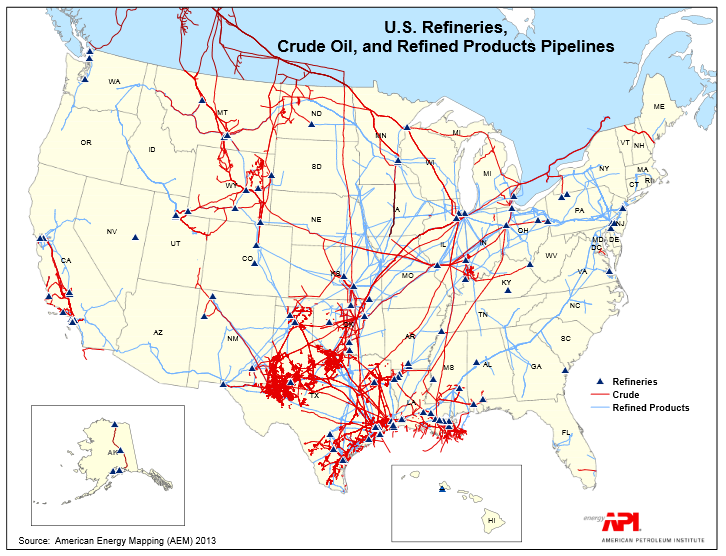
The map clearly shows why west coast gasoline and oil prices are decoupled from east of the rockies. Note no crude pipelines and only really one product pipeline, going to the west coast.
The other interesting feature is how the WWII big inch pipeline from Tx up to Washington DC shows up and its clear that it was built to avoid putting tankers in the way of u boats. It also shows why a shutdown of this pipeline puts the southeast in a world of hurt.
Actually, the Big Inch and Little Big Inch ran west of the Mississippi and North of the Ohio, and terminated in New Jersey and Pennsylvania. That pipeline through the southeast is a different one, but your point about a shutdown is correct. http://en.wikipedia.org/wiki/Big_Inch
Wickedgreen I agree with your point that maps can be deceptive – in fact that is one reason the National Energy Board (Canada’s interprovincial pipeline regulator) does not allow them into evidence!
e.g. How do you cross examine a map?


ooooo, I love maps! Especially spaghetti maps. Although Texas looks more like a shotgun wound, but I disgress …
Still, it just isn’t busy enough. Everyone knows where state boundaries are.
How about slapping some major fault lines, or important aquifer recharge areas, or regions of high biological diversity/endemism, or intersecting zones of minority/low income populations, or I dunno, anything that tells us about reality – you know, in context?
It’s as simple to obscure with maps as it is to inform. Easier, in fact.
Toilet of the U.S., thy names are Texas and Loosiana. ;)
The map clearly shows why west coast gasoline and oil prices are decoupled from east of the rockies. Note no crude pipelines and only really one product pipeline, going to the west coast.
The other interesting feature is how the WWII big inch pipeline from Tx up to Washington DC shows up and its clear that it was built to avoid putting tankers in the way of u boats. It also shows why a shutdown of this pipeline puts the southeast in a world of hurt.
Actually, the Big Inch and Little Big Inch ran west of the Mississippi and North of the Ohio, and terminated in New Jersey and Pennsylvania. That pipeline through the southeast is a different one, but your point about a shutdown is correct. http://en.wikipedia.org/wiki/Big_Inch
We already have crude pipeline from North Dakota to Texas. Why not use that for tar sands instead of Keystone?
As to the the Ogallala Acquifer, a map is included in this opinion piece:
http://oilprice.com/Energy/Oil-Prices/Why-I-Would-Approve-The-Keystone-XL-Pipeline-Despite-Environmental-Concerns.html
A better map is here:
http://www.threedonia.com/wp-content/uploads/2012/01/ogallala_aquifer_map-2.jpg
Wickedgreen I agree with your point that maps can be deceptive – in fact that is one reason the National Energy Board (Canada’s interprovincial pipeline regulator) does not allow them into evidence!
e.g. How do you cross examine a map?